Home › Campaign routes › First fall 1569
The first fall of Ayutthaya, 1569: the camps, the way in and what was lost
Late in 1568 King Bayinnaung of Pegu laid siege to Ayutthaya again. He placed his royal camp at Wat Maheyong in the east and built three earthen causeways across the moat on that side. When storming failed he sent Phraya Chakri in as a spy, and the city fell in August 1569. This page maps the Pegu camps, shows where the army broke in, lists what Ayutthaya lost and what can still be seen, and suggests places to visit and eat near each spot.
- Burmese camp (numbers match the list below)
- Where the enemy got in
- Area shown in the close-up map below
- Other places on our map
What happened, in order
- Late 1568
The Pegu army reaches Ayutthaya. Bayinnaung camps on the Lumphli plain, comes under fire from the great gun Narai Sanghan at the Wat Sop Sawan corner and pulls back towards Maha Phram.
- The siege
The army rings the city on every side, with the royal camp at Wat Maheyong. On the east its stockades advance towards the moat in three stages, taking more than two months to reach the edge.
- During the siege
King Maha Chakkraphat falls ill and dies; King Mahin takes over the defence.
- About three months
The Pegu army builds three causeways across the front moat. Meanwhile a Lan Xang army coming to relieve Ayutthaya is ambushed and routed near Saraburi.
- Late in the siege
Phraya Chakri pretends to escape into the city on the Wat Sop Sawan side, is given command of the defence, fights in earnest for about a month and then undermines it from within.
- August 1569
The Pegu army attacks by all three causeways at once. Phra Maha Thep's force breaks at the Ko Kaeo corner and Ayutthaya falls.
- After the fall
King Mahin is brought to Wat Maheyong. Bayinnaung installs Maha Thammaracha as king, then carries people and treasure back to Pegu.
- 1577–1580
King Maha Thammaracha builds Chan Kasem Palace, widens the front moat and moves the east wall out to the water's edge.
- 1584
Naresuan declares independence at Khraeng.
Where the Burmese camped
The chronicles say the Pegu army surrounded the city on every side: the Uparaja and Maha Thammaracha on the east (the 'front'), the King of Ava on the south, Phraya Thala, the Shan lords and the lord of Chiang Mai on the west, and the lords of Bassein and Toungoo on the north. The places they actually name, and that can be put on a map, are these.
Bayinnaung's royal camp at Wat Maheyong
Bayinnaung's royal camp, where King Mahin was brought after the fall
Today: The ruins of Wat Maheyong with its elephant-supported chedi, next to a meditation centre.
Show on the mapGoogle Maps ↗Details, sights and food nearby →
Bayinnaung's first camp on the Lumphli plain
The first camp on arrival, abandoned under cannon fire
Today: The Lumphli plain is farmland and villages today, with no trace of the camp. Wat Phu Khao Thong and the King Naresuan the Great monument are close by.
Show on the mapGoogle Maps ↗Details, sights and food nearby →
The King of Ava's camp at Wat Saphan Kluea
Base of the northern causeway, the King of Ava's
Today: An abandoned temple site on Ko Loi with a bell tower and brick remains among houses; a footbridge links Ko Loi with the city island.
Show on the mapGoogle Maps ↗Details, sights and food nearby →
The King of Prome's camp at Wat Chan, opposite Bang Ian
Base of the middle causeway, the King of Prome's
Today: The Wat Chan on this bank is a vanished temple with no buildings left; a large bodhi tree stands by the river near the ferry to the city island, in the neighbourhood in front of the railway station.
Show on the mapGoogle Maps ↗Details, sights and food nearby →
Burmese camp at Ko Kaeo
Base of the southern causeway, the one that got in
Today: Wat Ko Kaeo is an active temple with a Late Ayutthaya-style ordination hall facing the Pa Sak River and a shrine to King Taksin.
Show on the mapGoogle Maps ↗Details, sights and food nearby →
Burmese camps on the Phaniat plain
The northern plain where Pegu armies camped in both the White Elephant War and this one
Today: The elephant kraal seen today was restored in the Rattanakosin period and can be visited from the Phu Khao Thong–Phaniat road.
Show on the mapGoogle Maps ↗Details, sights and food nearby →
Where they broke in
Ayutthaya had rivers on three sides. On the east there was only the front moat, then a small channel, and the east wall still stood further back along the line of Khlong Makham Riang. The land between wall and moat was the city's weakest ground. The chronicles say Bayinnaung judged this the only side that could be attacked, ordered a year's supplies, and moved his stockades towards the moat stage by stage.
The Pegu army built three causeways across the moat: the northern one from Wat Saphan Kluea, the middle one from Wat Chan and the southern one at Ko Kaeo, working behind shields of palm logs while Siamese fire killed many of the labourers. The chronicle says it took three months for the causeways to reach the wall side. An attack by the Ko Kaeo causeway broke down the wall at that corner, but the Siamese fell back to an inner stockade and held the city.
The city fell only when there was a spy inside. Phraya Chakri, who had pretended to escape, was given command of the defence. After a month of fighting in earnest he punished the best commanders and reshuffled the troops until the lines were weak, then sent a secret letter naming the day for the Pegu army to attack by all three causeways at once. Phra Maha Thep's force at the Ko Kaeo corner fell back to Wat Kho, Wat Krabue and Wat Phao Khao before it broke up.
- Burmese camp; numbers match the list of camps above
- Causeways across the front moat; A, B and C match the list below
- The Ko Kaeo corner, where the enemy got in
- The east wall before it was moved out to the water (assumed to follow Khlong Makham Riang)
- Built after the first fall
Northern causeway, from Wat Saphan Kluea to the Wat Khwang bank
Where: The Front City Canal (the old front moat) between Ko Loi and the north-east corner of the city island, east of where Chan Kasem Palace was later built approximate
The northern Pegu causeway crossed the front moat from the camp at Wat Saphan Kluea to the city bank near Wat Khwang. In 1569 the east wall still stood further back, along the line of Khlong Makham Riang, so the land beside the moat lay outside the wall and was held only by Siamese timber stockades. On the day of the final assault the King of Ava's men crossed here at the same time as the other two columns.
Today: This stretch of the old moat is the Front City Canal between Ko Loi and the city island. On the city side is the Chan Kasem Palace quarter, built after the war to close this weak corner.
Still debated: No archaeological trace of the causeway is known; the map point is estimated from the two temples the chronicle names.
Middle causeway, from Wat Chan to Bang Ian
Where: The Pa Sak River (the old front moat) in front of Ayutthaya railway station, in line with Khlong Bang Ian inside the city island approximate
The middle causeway crossed the front moat from the camp at Wat Chan to the Bang Ian bank. The chronicle says the Siamese held a line of timber stockades along the moat and that from the Ho Rattanachai gate down to Ko Kaeo there was only a moat, with no river in front. This was the side on which Bayinnaung concentrated his effort. In the final assault the King of Prome's men crossed here.
Today: The old front moat was only a small channel; today it is the Pa Sak River, with a ferry between the pier at the railway station and the city island.
Still debated: The positions of Wat Chan and Bang Ian are conjectures based on a vanished temple on the east bank and the line of Khlong Bang Ian inside the island.
Southern causeway and the Ko Kaeo corner, where the city was entered
Where: The Pa Sak River at Wat Ko Kaeo, by the south-east corner of the city island; the city side is the Wat Rattanachai neighbourhood approximate
The southern causeway ran from the camp at Ko Kaeo across the front moat to the south-east corner of the city. The chronicle says the Pegu troops crossed it with boats on both flanks; the Siamese fell back to an inner stockade and the enemy broke down the wall at the Ko Kaeo corner, but still could not take the city. Only after Phraya Chakri had gone in as a spy and sent out the day did the Pegu army attack by all three causeways at once. The Uparaja and Maha Thammaracha came in at the Ko Kaeo corner. Phra Maha Thep, who held this side, fell back to make a stand in front of Wat Kho and Wat Krabue, then at Wat Phao Khao, where his force broke up. Ayutthaya fell to the King of Pegu in August 1569.
Today: The city side here is the Wat Rattanachai neighbourhood on U-Thong Road, with Wat Ko Kaeo on the far bank. Nothing of the wall or the causeway can be seen. Pom Phet fortress is less than half a kilometre to the west.
Still debated: The two versions of the chronicle disagree on who commanded this causeway (the Uparaja or the King of Ava), and the date of the fall converts to 2, 7 or 30 August 1569 depending on the source. The map point is estimated from the positions of Wat Ko Kaeo and Wat Rattanachai.
The Wat Sop Sawan side, where the spy Phraya Chakri entered
Where: The west wall of the city near Wat Sop Sawan, on the Chao Phraya; Wat Thammaram stands on the opposite bank approximate
The chronicles say that when the city could not be stormed, Maha Thammaracha drew Phraya Chakri, an Ayutthaya noble taken to Pegu after the White Elephant War, into a ruse, and Bayinnaung approved it. Phraya Chakri was put in irons under thirty guards; five or six days later he was let slip into the city at night, still in his fetters, through the sector Phraya Thamma held at Wat Sop Sawan. Next morning the thirty guards were executed and impaled in front of a stockade. King Mahin believed the escape was real and gave Phraya Chakri command of the defence. He fought in earnest for about a month, then began punishing the commanders who fought hardest and swapping soldiers with civil officials until the defence weakened, and sent out a secret letter naming the day to attack.
Today: Nothing remains of Wat Sop Sawan; the site lies in a military area near the Si Suriyothai chedi. Wat Thammaram across the river is an active temple with an old ordination hall and a white bell-shaped chedi.
Still debated: The Royal Autograph Chronicle says the guards were impaled “in front of the camp at Wat Tharama”. ayutthaya-history.com links the name with Wat Thammaram on the west bank, while the English translation it follows calls it Phraya Thamma's stockade, so it is not certain where this stockade stood or whose it was. Beyond Phraya Chakri, the historian Phiset Chiachanphong argues that members of the royal household inside the city also favoured Pegu.
What was destroyed and carried off
Unlike the second fall, the chronicles record no burning of the city this time. Bayinnaung installed a new king to rule on as his vassal, so what Ayutthaya lost was people, royal treasure and independence rather than buildings.
- Taken awayMost of the population
The chronicles say the King of Pegu carried the townspeople off to Pegu, leaving 100 officials and about 10,000 commoners for Maha Thammaracha to hold the city with.
- Taken awayThe king and independence
King Mahin was taken away to Pegu and died on the journey. Ayutthaya remained a vassal of Pegu for 15 years.
- Taken awayThe bronze figures of Wat Phra Si Sanphet
The Testimony of Khun Luang Ha Wat says the King of Pegu picked out bronze figures that stood in Wat Phra Si Sanphet: the Erawan elephant, a horse, lions and human figures. The chronicles also mention 'all the images' being carried away.
- DamagedAn arm of the Phra Si Sanphet image
Nicolas Gervaise, a Frenchman in Ayutthaya in King Narai's reign, recorded that the great standing Buddha had once had an arm cut off in a war with Pegu.
- DamagedThe wall at the Ko Kaeo corner and the moat stockades
The wall at the south-east corner was broken down and the line of timber stockades along the front moat was overrun.
- PeopleSiamese commanders and princes
During negotiations Ayutthaya had to hand over Phraya Ram, who commanded the defence, and Prince Si Saowarat, another son of King Chakkraphat, was put to death at Wat Phra Ram on King Mahin's order.
- SparedWhat was spared
The palace and the royal temples in the heart of the city stood; Maha Thammaracha took the throne in the same palace.
Evidence you can still see
More than 450 years have passed and the city was wrecked again in 1767, so little is left from the first war. Some real traces can still be seen, in Ayutthaya and in Myanmar.
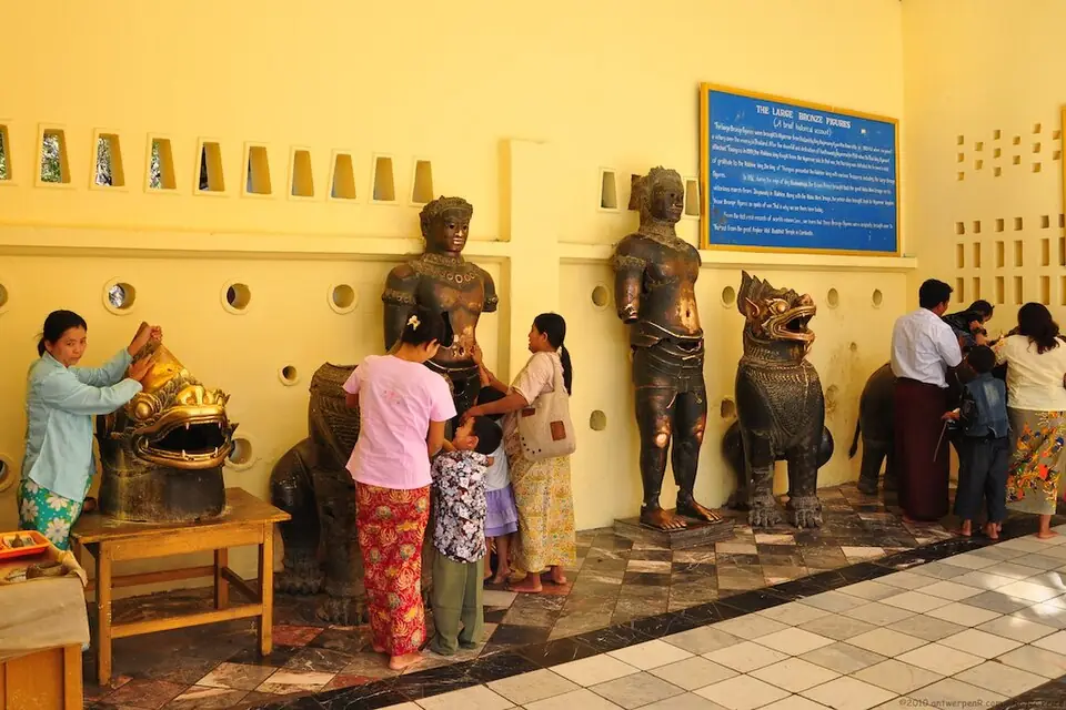
The Ayutthaya bronzes at Mahamuni Temple, Mandalay
The most important evidence of this war is outside Thailand. The bronzes Bayinnaung took from Ayutthaya were seized again and carried to Arakan in 1599, then to Amarapura in 1784. Six survive at Mahamuni Temple, where people rub them in the belief that this cures illness, and two more have been reported at Toungoo.
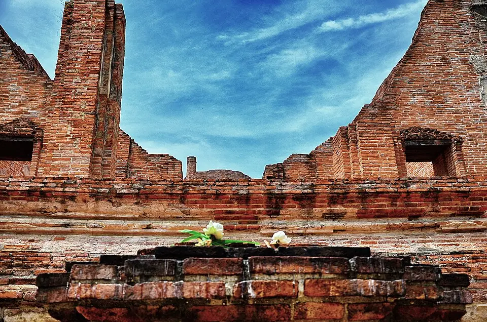
Wat Maheyong, site of the royal camp
Wat Maheyong already stood here when Bayinnaung made it his royal camp. The elephant-ringed chedi and ordination hall seen today were heavily restored under King Thai Sa, but this is the place where King Mahin was brought after the fall.
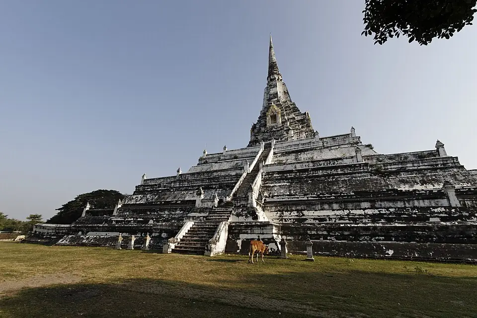
The base of the Phu Khao Thong chedi
The three-tiered redented square base of the chedi is in Mon-Burmese style. The historian Phiset Chiachanphong argues it is the part Bayinnaung built around 1569; the Thai-style chedi on top dates from King Borommakot's restoration of 1744.
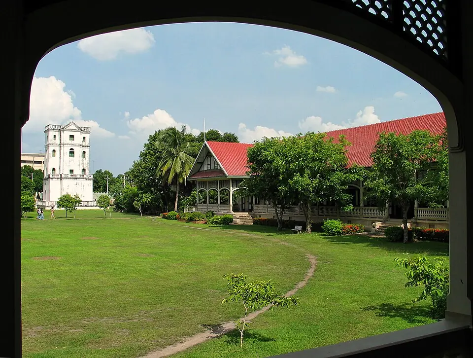
Chan Kasem Palace and the wall moved to the river
The direct result of this defeat was a new line of defence on the east. King Maha Thammaracha built Chan Kasem Palace around 1577, widened the front moat and moved the wall out to the water. The widened moat became the main course of today's Pa Sak River.
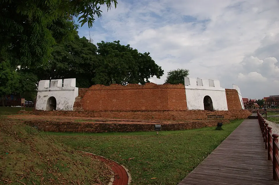
Pom Phet, near the Ko Kaeo corner
Pom Phet stands a few hundred metres from the Ko Kaeo corner, guarding the mouth of the Pa Sak. The riverside wall running north from it is the line moved out after the first fall, and the fort's brick ramparts give an idea of the new defences.
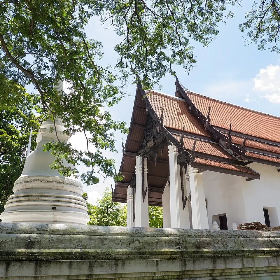
Wat Thammaram, across the river from the spy's entry
Wat Thammaram is on the west bank of the Chao Phraya, opposite the Wat Sop Sawan side where Phraya Chakri entered the city. The Royal Autograph Chronicle says his thirty guards were executed and impaled “in front of the camp at Wat Tharama”, which ayutthaya-history.com links with this temple. It is an active temple and open to visitors.
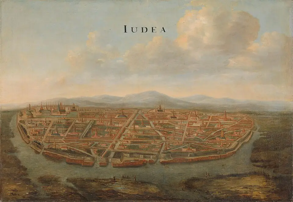
The riverside walls in a Dutch painting
Johannes Vingboons's view of Ayutthaya, painted around 1662, shows the island city walled along the water on every side, as it was after the east wall was moved out, some eighty years after the first fall. The original is in the Rijksmuseum, Amsterdam.
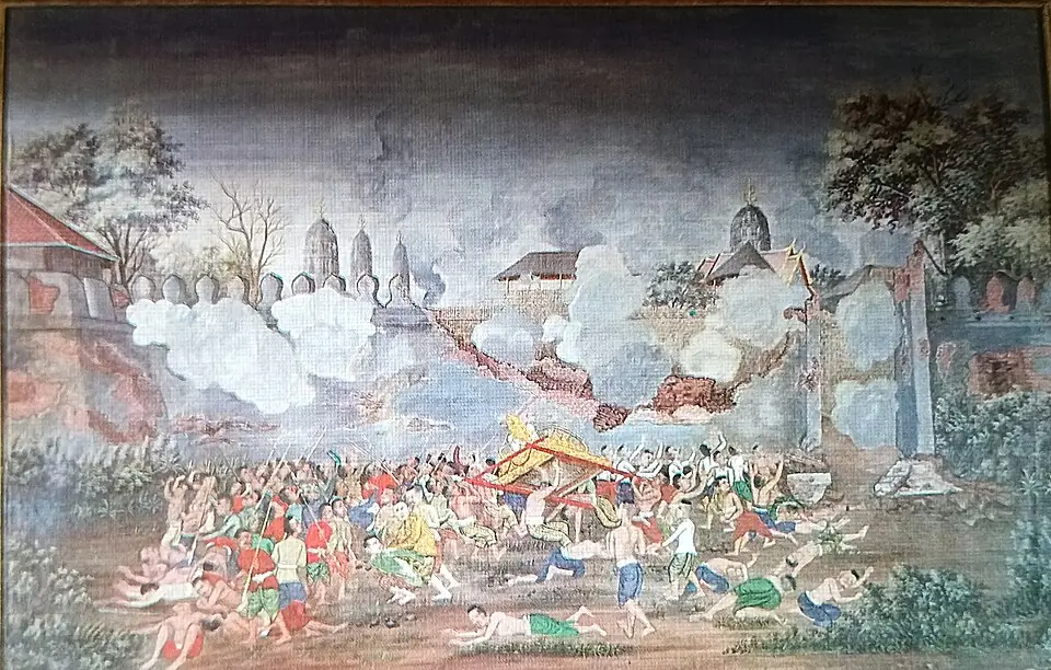
A painting from 1887 (not contemporary evidence)
The series of chronicle paintings King Chulalongkorn commissioned in 1887 includes the scene of Maha Thammaracha coming forward to negotiate and being fired on from the city. It is an artist's imagining three centuries later: good as an illustration, but not evidence of the event.
Places to visit and eat nearby
The key places of this war lie all round the city island. We group them into five areas, each good for half a day.
The eastern fields: Wat Maheyong, the royal camp
Bayinnaung's royal camp stood in the middle of the eastern fields. Today it is a cluster of ruins close together: park at Wat Maheyong and go on to Wat Kudi Dao and Wat Samanakottharam in half a day.
In this area:1Wat Maheyong royal camp
Places to visit
- Wat MaheyongA chedi ringed by some 80 elephants, and the site of King Bayinnaung's royal camp when Ayutthaya first fell in 1569
- Wat Kudi DaoAn abandoned temple in the eastern fields, restored by King Borommakot, who was also ordained here while he was still the Front Palace prince
- Wat Samana KotA temple off the island to the east with an unusual five-spired chedi, said to be the temple of the family of Kosa Lek and Kosa Pan
- Wat AyothayaA temple that legend ties to the city of Ayothaya before Ayutthaya, with a large cracked chedi in a still-active temple
Where to eat
- Khaotom Chedi (ข้าวต้มเจดีย์)near Wat Samana KotDishes to eat with plain rice soup; the menu changes with each day's ingredients
- Kha Mu Jae Mhai (ขาหมูเจ๊ไหม)near Wat Samana KotFive-spice braised pork leg with pickled mustard greens, egg and blanched Chinese kale
- Khanom Mho Kaeng Mae Yai, Phai Ling Branch (ขนมหม้อแกงแม่ยาย สาขาไผ่ลิง)near Wat Samana KotKhanom mo kaeng (Thai custard cake), sweet millet pudding, thua paep, piak pun jelly
- Ayothaya Floating Market (ตลาดน้ำอโยธยา)near Wat Samana KotThai food and sweets sold from boats, canal boat rides
- Restaurants in this area on Google Maps ↗
The front: Hua Ro, Chan Kasem Palace and the railway station side
The northern and middle causeways crossed the Front City Canal and the Pa Sak along this stretch. Start at Chan Kasem Palace, walk to Hua Ro market, then take the ferry at the railway station to see the old front moat from midstream.
In this area:3Wat Saphan Kluea campANorthern causeway4Wat Chan campBMiddle causeway
Places to visit
- Chandra Kasem PalaceThe palace built as King Naresuan's residence, and his command post for defending the capital
- Wat SenasanaramAyutthaya's first Thammayut temple, revived by King Rama IV from the ruined Wat Suea behind Chandra Kasem Palace
- Wat Saphan Kluea (Ko Loi) ↗Google Maps
- Ferry pier at Ayutthaya railway station ↗Google Maps
Where to eat
- Hua Ro Market (ตลาดหัวรอ)near Chandra Kasem PalaceFresh produce, ready-made dishes and local sweets
- Je Ni's Rice Porridge (โจ๊กเจ๊นิ), Hua Ro Marketnear Chandra Kasem PalaceHot rice porridge (jok) for breakfast
- Buk's Red Pork Rice (บั๊กข้าวหมูแดง), Hua Ro Marketnear Chandra Kasem PalaceRed roast pork and crispy pork on rice
- Nai Liak Beef Noodles (ก๋วยเตี๋ยวเนื้อนายเลียก)near Chandra Kasem PalaceBeef noodles with stewed beef, offal and beef balls
- Restaurants in this area on Google Maps ↗
The Ko Kaeo corner, Pom Phet and Wat Phanan Choeng
The spot where the city was entered is less than a kilometre from Pom Phet. See the riverside ramparts at the fort and the murals at Wat Suwan Dararam, then cross to the great Buddha of Wat Phanan Choeng. Several riverside restaurants here serve river prawns.
In this area:5Ko Kaeo campCKo Kaeo corner, 1569 breach
Places to visit
- Wat Suwan DararamThe temple of the Chakri dynasty's ancestors, whose wihan walls are painted with the life of King Naresuan and the elephant duel
- Phet FortressA corner fort of the capital where the rivers meet, guarding the foreign-ship landing; one of only two surviving forts of Ayutthaya
- Wat Phanan ChoengA temple older than Ayutthaya itself, home of the great Luang Pho To, revered by Thai and Chinese worshippers alike
- Baan HollandaSite of the Dutch trading post, a relationship that began when VOC merchants were received by Naresuan
- Wat Ko Kaeo ↗Google Maps
- Wat Rattanachai ↗Google Maps
Where to eat
- Baan Pomphet (บ้านป้อมเพชร)near Phet FortressGrilled river prawns and freshwater shellfish dishes
- Phae Krung Kao (แพกรุงเก่า)near Wat Phanan ChoengCharcoal-grilled river prawns, green curry with clown knifefish balls
- Restaurants in this area on Google Maps ↗
The Lumphli plain and Wat Phu Khao Thong
Bayinnaung's first camp lay on the same plain as the Phu Khao Thong chedi. Climb the base of the chedi for a view over the fields, then stop at the King Naresuan the Great monument next door.
In this area:2Lumphli camp6Phaniat camps
Places to visit
- Wat Phu Khao ThongThe chedi King Bayinnaung built after the first fall of Ayutthaya, in the middle of a former battlefield
- Wat Choeng ThaThe 'waiting at the landing' temple opposite the Royal Palace, with a legend of a rich man's runaway daughter and the story that King Taksin once studied here
- King Naresuan the Great Monument, Thung Phu Khao Thong ↗Google Maps
Where to eat
- Pranom Shredded Chicken Noodles, Tha Wasukri Branch (ก๋วยเตี๋ยวไก่ฉีก คุณประนอม สาขาท่าวาสุกรี)near Wat Na Phra MenShredded-chicken noodles in tom yum broth, braised chicken feet
- Wat Tha Ka Rong Floating Market (ตลาดน้ำวัดท่าการ้อง)near Wat Tha Ka RongAyutthaya boat noodles and riverside snacks
- Rimsuan Restaurant (ร้านริมสวน)near Suriyothai ChediSouthern Thai food, yellow curry with river fish
- Ayutthayaromnear Suriyothai ChediTom som (sour soup) with squid and fresh chillies, fried river fish in chu chee curry, Thai desserts with fresh coconut milk
- Restaurants in this area on Google Maps ↗
The west side: Wat Sop Sawan, the Si Suriyothai chedi and Wat Thammaram
The side where Phraya Chakri came in is next to the Si Suriyothai chedi. Across the river on the west bank are Wat Thammaram and Wat Kasattrathirat, with several riverside restaurants around Wat Thammaram.
In this area:DPhraya Chakri's entry
Places to visit
- Suriyothai ChediA memorial to Queen Suriyothai, King Naresuan's grandmother
- Wat Sop SawanA temple born of Queen Suriyothai's funeral, and one of the places where King Naresuan may have been cremated.
- Wat KasattrathiratA riverside temple on the west bank facing the city island, with a stout main prang and an old ubosot still in use
- Wat Tha Ka RongA riverside temple on the Chao Phraya where the Burmese set up a camp and positioned cannon to besiege the capital during the fall of Ayutthaya in 1767.
- Wat LokayasutharamThe largest open-air reclining Buddha on the city island, lying just behind the Ancient Royal Palace.
- Wat Thammaram ↗Google Maps
Where to eat
- Rimsuan Restaurant (ร้านริมสวน)near Suriyothai ChediSouthern Thai food, yellow curry with river fish
- Ayutthayaromnear Suriyothai ChediTom som (sour soup) with squid and fresh chillies, fried river fish in chu chee curry, Thai desserts with fresh coconut milk
- Kaow Laor (ขาวละออ)near Suriyothai ChediRiver prawns, river fish, clown knifefish cakes
- Wat Tha Ka Rong Floating Market (ตลาดน้ำวัดท่าการ้อง)near Wat Tha Ka RongAyutthaya boat noodles and riverside snacks
- Restaurants in this area on Google Maps ↗
After the fall: Ayutthaya rebuilds its defences
The lesson of this war changed the shape of the city. King Maha Thammaracha built Chan Kasem Palace at the north-east corner, had the front moat dug ten wa wide and three wa deep (about 20 by 6 metres) from Maha Chai Fortress down to Bang Kacha, and moved the wall out to the water's edge. The Luang Prasoet chronicle dates this to 1580. The current scoured the widened moat until it became the main course of the Pa Sak River. The river-ringed island seen today is a direct result of the first fall.
These were the defences Naresuan used against Nanda Bayin's siege of 1586–87. They served until the second fall, when the enemy had to tunnel under the wall at Hua Ro and fire its foundations to get in.
Where historians still disagree
- The date of the fall: Thai chronicles give the 11th waning day of the 9th month (a Sunday in CS 931 in the Luang Prasoet chronicle; a Saturday in the Royal Autograph version, which also misdates the year to CS 918). Converted to the Western calendar, sources give 2 August, 7 August or 30 August 1569.
- Who held which causeway: the Royal Autograph Chronicle puts the King of Ava at Wat Saphan Kluea, the King of Prome at Wat Chan and the Uparaja at Ko Kaeo; an older version has the Uparaja's division building the causeways to Wat Fang and Bang Ian, and the King of Ava the one at the Ko Kaeo corner.
- Who the traitors were: the Thai chronicles say Maha Thammaracha recruited Phraya Chakri as the spy. The historian Phiset Chiachanphong argues that the figure the chronicles call 'the inner lord of life', whom he identifies as Queen Wisutkasattri, also favoured Pegu.
- How many people were left: the chronicles say 10,000 commoners; some summaries say 1,000.
- Where the bronzes came from: the Testimony of Khun Luang Ha Wat says they were cast under King U Thong, but many scholars see them as Khmer sculptures Ayutthaya carried off from Angkor in 1431.
- Who built the Phu Khao Thong chedi: its Mon-Burmese base leads Phiset Chiachanphong to credit Bayinnaung around 1569, matching the Burmese chronicle's 'relic chedi built by the White Elephant King of Pegu'; local legend and foreign accounts from the Ayutthaya period tell it differently.
Frequently asked questions
When was the first fall of Ayutthaya?
On the 11th waning day of the 9th lunar month, in August 1569, in the reign of King Mahin, after Bayinnaung's army had besieged the city for about nine months. Sources convert the date as 2, 7 or 30 August.
Where did the Burmese break in the first time?
On the east, where only the front moat protected the city. The Pegu army built three causeways across it and got in at the Ko Kaeo corner, the south-east corner of the island near today's Pom Phet, with Phraya Chakri working as a spy inside.
Where were the Burmese camps in 1569?
Bayinnaung's royal camp was at Wat Maheyong and his first camp on the Lumphli plain. The causeways started from camps at Wat Saphan Kluea, Wat Chan and Ko Kaeo, and there were camps on the Phaniat plain to the north.
Was the city burned in 1569?
The chronicles record no burning like that of 1767. Bayinnaung left Maha Thammaracha to rule as a vassal, but carried off most of the population, the bronze figures and other treasure to Pegu.
Where can you see traces of the first fall?
In Ayutthaya: Wat Maheyong (the royal camp), the base of the Phu Khao Thong chedi, Chan Kasem Palace and Pom Phet (the defences built afterwards) and the Wat Ko Kaeo area where the city was entered. The bronzes that were carried off are at Mahamuni Temple in Mandalay.
How is the first fall linked to King Naresuan?
Naresuan was about 14 and living in Pegu as a hostage, as he had been since the White Elephant War. His father, Maha Thammaracha, marched with Bayinnaung and was made king of Ayutthaya after the fall. Fifteen years later Naresuan declared independence.
How did the first fall differ from the second?
In 1569 the enemy came in at the south-east corner over causeways built across the moat, helped by a spy inside; there is no record of the city being burned, and it remained a capital, as a vassal of Pegu. In 1767 the enemy tunnelled under the wall at Hua Ro, the north-east corner, and fired its foundations; the city was sacked and burned and never became the capital again.
- Royal Autograph Chronicle (1912 edition), part 1, chapter 19 – Thai Wikisource (in Thai)
- Royal Autograph Chronicle (1912 edition), part 1, chapter 20 – Thai Wikisource (in Thai)
- First fall of Ayutthaya – Thai Wikipedia (in Thai)
- Burmese–Siamese War (1568–1569) – Wikipedia
- Ayutthaya's east wall, rebuilt after the first fall – Silpa Wattanatham (in Thai)
- The bronze figures of Toungoo and the first fall of Ayutthaya – Silpa Wattanatham (in Thai)
- Phra Si Sanphet, the great Buddha image whose appearance remains a mystery – Silpa Wattanatham (in Thai)
- Bayinnaung, 'Conqueror of the Ten Directions', built Phu Khao Thong at Ayutthaya – Silpa Wattanatham (in Thai)
- Was Queen Wisutkasattri on the Burmese side in the first fall? – Silpa Wattanatham (in Thai)
- Ayutthaya City Walls 1569 – Ayutthaya Historical Research
- Khlong Khue Na (the front moat) – Ayutthaya Historical Research
- Wat Ko Kaeo – Ayutthaya Historical Research
- Wat Saphan Kluea – Ayutthaya Historical Research
- Wat Thammaram – Ayutthaya Historical Research
- Wat Maheyong – Ayutthaya Historical Research
Last updated 14 November 2026